Macultepec night lights from space
Night Light of Macultepec (Tabasco) from space (Mexico) Src. Average luminocity for 10x10km area is 27.6558% and for 50x50km: 21.5907%.
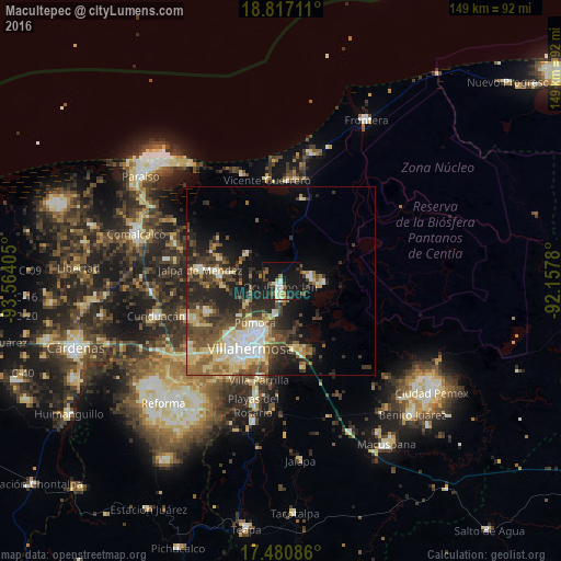
Analysis of Macultepec night lights 2016
Square area 10x10 km:
 1.95%
1.95%90-99
6.49%80-89
1.95%70-79
2.6%60-69
1.08%50-59
5.41%40-49
3.25%30-39
5.41%20-29
6.71%10-19
43.07%0-9
22.08%Square area 50x50 km:
2.54%90-99
3.5%80-89
4.44%70-79
1.51%60-69
2.54%50-59
3.64%40-49
4.47%30-39
4.59%20-29
6.12%10-19
10.07%0-9
56.58%Clear (daylight) street map image can be seen on geolist.org.
Map coordinates:
18° 49' 1.6" North, 93° 33' 50.6" West
18° 9' 0.9" North, 92° 51' 39.3" West
17° 28' 51.1" North, 92° 9' 28.1" West
Some cities around Macultepec sort by population:
• Villahermosa
19.6 km =12.2 mi,  201°
201°
• Jalpa de Méndez
21.5 km =13.4 mi,  277°
277°
• Nacajuca
16.8 km =10.4 mi, 277°
• Pomoca
13.4 km =8.3 mi,  213°
213°
• Tamulte de las Sabanas
8.3 km =5.2 mi,  81°
81°
• Bosque de Saloya
18.1 km =11.2 mi, 214°
• Medellín y Madero Segunda Sección
4.2 km =2.6 mi,  169°
169°
• La Selva
17.8 km =11.1 mi,  217°
217°
3523794 (p: 6,485)
Sources (retrieved 2019-11-25):
» Earth at Night: Flat Maps 2012, 2016