Santiago Tuxtla night lights from space
Night Light of Santiago Tuxtla (Veracruz) from space (Mexico) Src. Average luminocity for 10x10km area is 8.626% and for 50x50km: 2.4658%.
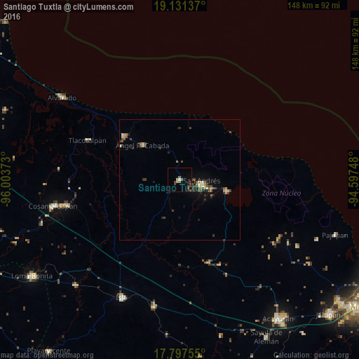
Analysis of Santiago Tuxtla night lights 2016
Square area 10x10 km:
 0.62%
0.62%90-99
0.21%80-89
0%70-79
1.65%60-69
1.65%50-59
0.83%40-49
4.55%30-39
1.24%20-29
0%10-19
3.1%0-9
86.16%Square area 50x50 km:
0.07%90-99
0.26%80-89
0.23%70-79
0.41%60-69
0.26%50-59
0.41%40-49
0.75%30-39
0.59%20-29
0.5%10-19
1.19%0-9
95.33%Clear (daylight) street map image can be seen on geolist.org.
Map coordinates:
19° 7' 52.9" North, 96° 0' 13.4" West
18° 27' 56.7" North, 95° 18' 2.2" West
17° 47' 51.2" North, 94° 35' 50.9" West
Some cities around Santiago Tuxtla sort by population:
• San Andrés Tuxtla
9.4 km =5.8 mi,  101°
101°
• Catemaco
20.3 km =12.6 mi, 104°
• Lerdo de Tejada
29.4 km =18.3 mi,  308°
308°
• Carlos A. Carrillo
48.9 km =30.4 mi,  258°
258°
• Ángel R. Cabada
21.1 km =13.1 mi, 313°
• Tlacotalpan
41.2 km =25.6 mi,  293°
293°
• Juan Díaz Covarrubias
36.1 km =22.4 mi,  160°
160°
• Comoapan
14.9 km =9.3 mi,  116°
116°
3516912 (p: 15,459)
Sources (retrieved 2019-11-25):
» Earth at Night: Flat Maps 2012, 2016