Juan Díaz Covarrubias night lights from space
Night Light of Juan Díaz Covarrubias (Veracruz) from space (Mexico) Src. Average luminocity for 10x10km area is 6.5% and for 50x50km: 1.0692%.
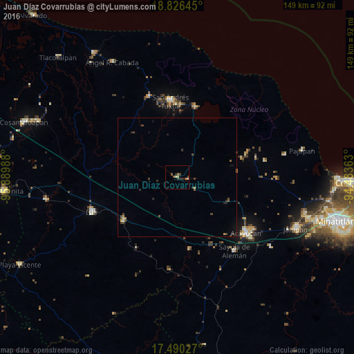
Analysis of Juan Díaz Covarrubias night lights 2016
Square area 10x10 km:
 0%
0%90-99
0.43%80-89
0.87%70-79
1.73%60-69
0.87%50-59
1.73%40-49
0.43%30-39
2.38%20-29
2.81%10-19
0%0-9
88.74%Square area 50x50 km:
0%90-99
0.06%80-89
0.07%70-79
0.23%60-69
0.08%50-59
0.21%40-49
0.39%30-39
0.33%20-29
0.32%10-19
0.35%0-9
97.94%Clear (daylight) street map image can be seen on geolist.org.
Map coordinates:
18° 49' 35.2" North, 95° 53' 23.6" West
18° 9' 34.7" North, 95° 11' 12.3" West
17° 29' 25" North, 94° 29' 1.1" West
Some cities around Juan Díaz Covarrubias sort by population:
• San Andrés Tuxtla
32.3 km =20.1 mi,  355°
355°
• Acayucan
37.1 km =23.1 mi,  128°
128°
• Catemaco
30.1 km =18.7 mi,  14°
14°
• Santiago Tuxtla
36.1 km =22.4 mi,  340°
340°
• Mecayapan
37.5 km =23.3 mi,  79°
79°
• Soconusco
39 km =24.2 mi,  124°
124°
• Soteapan
34.2 km =21.3 mi, 76°
• Comoapan
27.5 km =17.1 mi,  2°
2°
3825090 (p: 6,091)
Sources (retrieved 2019-11-25):
» Earth at Night: Flat Maps 2012, 2016