Lerdo de Tejada night lights from space
Night Light of Lerdo de Tejada (Veracruz) from space (Mexico) Src. Average luminocity for 10x10km area is 8.5455% and for 50x50km: 1.1985%.
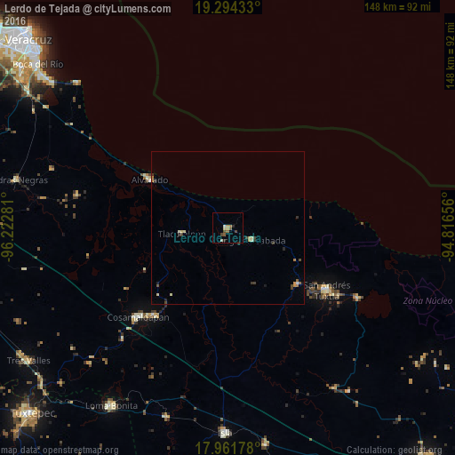
Analysis of Lerdo de Tejada night lights 2016
Square area 10x10 km:
 0%
0%90-99
1.65%80-89
0.83%70-79
1.24%60-69
1.45%50-59
2.27%40-49
2.48%30-39
0.41%20-29
1.65%10-19
0%0-9
88.02%Square area 50x50 km:
0.02%90-99
0.18%80-89
0.15%70-79
0.2%60-69
0.19%50-59
0.14%40-49
0.28%30-39
0.25%20-29
0.22%10-19
0.11%0-9
98.25%Clear (daylight) street map image can be seen on geolist.org.
Map coordinates:
19° 17' 39.6" North, 96° 13' 22.1" West
18° 37' 45.7" North, 95° 31' 10.8" West
17° 57' 42.4" North, 94° 48' 59.6" West
Some cities around Lerdo de Tejada sort by population:
• San Andrés Tuxtla
38 km =23.6 mi,  121°
121°
• Cosamaloapan
41.4 km =25.7 mi,  225°
225°
• Alvarado
30 km =18.6 mi,  301°
301°
• Carlos A. Carrillo
37.6 km =23.4 mi,  221°
221°
• Santiago Tuxtla
29.4 km =18.3 mi,  128°
128°
• Ángel R. Cabada
8.6 km =5.3 mi, 115°
• Tlacotalpan
14.8 km =9.2 mi,  263°
263°
• Comoapan
44 km =27.3 mi, 124°
3524391 (p: 18,715)
Sources (retrieved 2019-11-25):
» Earth at Night: Flat Maps 2012, 2016