Santander Jiménez night lights from space
Night Light of Santander Jiménez (Tamaulipas) from space (Mexico) Src. Average luminocity for 10x10km area is 2.9148% and for 50x50km: 0.2749%.
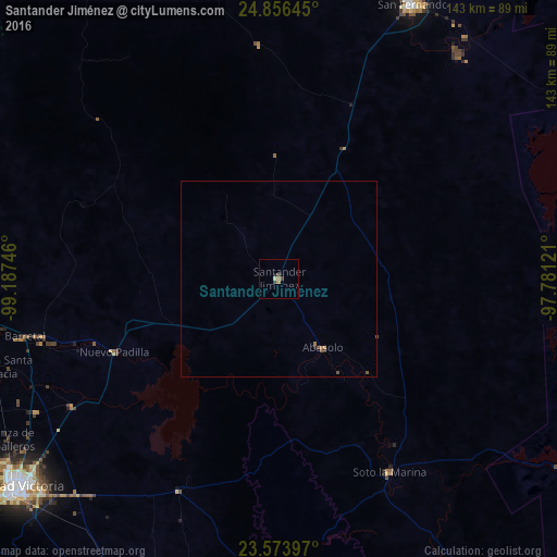
Analysis of Santander Jiménez night lights 2016
Square area 10x10 km:
 0%
0%90-99
0.19%80-89
0.57%70-79
0.38%60-69
1.14%50-59
0%40-49
1.52%30-39
0.76%20-29
0%10-19
0.76%0-9
94.7%Square area 50x50 km:
0%90-99
0.01%80-89
0.02%70-79
0.05%60-69
0.11%50-59
0.01%40-49
0.18%30-39
0.05%20-29
0.04%10-19
0.03%0-9
99.5%Clear (daylight) street map image can be seen on geolist.org.
Map coordinates:
24° 51' 23.2" North, 99° 11' 14.9" West
24° 13' 0.6" North, 98° 29' 3.6" West
23° 34' 26.3" North, 97° 46' 52.4" West
Some cities around Santander Jiménez sort by population:
• Ciudad Victoria
85.5 km =53.1 mi,  231°
231°
• San Fernando
77.9 km =48.4 mi,  25°
25°
• Soto la Marina
57.3 km =35.6 mi,  150°
150°
• Guillermo Zúñiga
76.1 km =47.3 mi,  252°
252°
• Estación Santa Engracia
76.2 km =47.3 mi, 252°
• Abasolo
20.9 km =13 mi, 147°
• Jaumave
128.2 km =79.7 mi, 225°
• Nueva Villa de Padilla
46.3 km =28.8 mi, 246°
3517151 (p: 5,504)
Sources (retrieved 2019-11-25):
» Earth at Night: Flat Maps 2012, 2016