San Nicolás Guadalupe night lights from space
Night Light of San Nicolás Guadalupe (México) from space (Mexico) Src. Average luminocity for 10x10km area is 14.5868% and for 50x50km: 14.1898%.
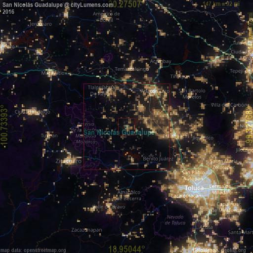
Analysis of San Nicolás Guadalupe night lights 2016
Square area 10x10 km:
 0%
0%90-99
0%80-89
0%70-79
0.83%60-69
3.31%50-59
4.55%40-49
4.75%30-39
6.4%20-29
2.89%10-19
8.68%0-9
68.6%Square area 50x50 km:
0.02%90-99
0.23%80-89
1.1%70-79
1.79%60-69
3.38%50-59
2.69%40-49
4.35%30-39
4.9%20-29
6.08%10-19
12.38%0-9
63.08%Clear (daylight) street map image can be seen on geolist.org.
Map coordinates:
20° 16' 30.3" North, 100° 44' 2.1" West
19° 36' 50.8" North, 100° 1' 50.9" West
18° 57' 1.6" North, 99° 19' 39.6" West
Some cities around San Nicolás Guadalupe sort by population:
• San Pedro de los Baños
21.4 km =13.3 mi,  73°
73°
• San Pedro Los Baños
21.9 km =13.6 mi,  86°
86°
• La Concepción de los Baños
19.3 km =12 mi, 66°
• Santa María Citendejé
21.5 km =13.4 mi,  29°
29°
• San Miguel Tenochtitlán
19.8 km =12.3 mi, 34°
• El Oro de Hidalgo
23.4 km =14.5 mi,  333°
333°
• Santiago Citendejé
21.4 km =13.3 mi, 29°
• San Juan Coajomulco
16.8 km =10.4 mi,  22°
22°
4026719 (p: 5,905)
Sources (retrieved 2019-11-25):
» Earth at Night: Flat Maps 2012, 2016