El Oro de Hidalgo night lights from space
Night Light of El Oro de Hidalgo (México) from space (Mexico) Src. Average luminocity for 10x10km area is 25.6715% and for 50x50km: 10.4362%.
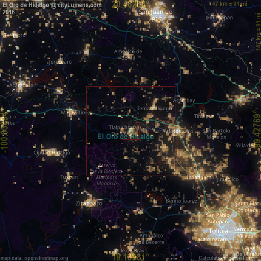
Analysis of El Oro de Hidalgo night lights 2016
Square area 10x10 km:
 0%
0%90-99
0.83%80-89
1.65%70-79
4.75%60-69
6.82%50-59
4.13%40-49
7.44%30-39
7.85%20-29
8.26%10-19
26.86%0-9
31.4%Square area 50x50 km:
0.02%90-99
0.11%80-89
0.7%70-79
1.12%60-69
2.52%50-59
1.76%40-49
3.22%30-39
3.41%20-29
3.22%10-19
10.83%0-9
73.08%Clear (daylight) street map image can be seen on geolist.org.
Map coordinates:
20° 27' 46.4" North, 100° 50' 2.2" West
19° 48' 9.8" North, 100° 7' 50.9" West
19° 8' 23.3" North, 99° 25' 39.7" West
Some cities around El Oro de Hidalgo sort by population:
• Temascalcingo
18.3 km =11.4 mi,  46°
46°
• San Lorenzo Tlacotepec
22.9 km =14.2 mi,  87°
87°
• San Francisco Tepeolulco
15.3 km =9.5 mi,  77°
77°
• Santa María Citendejé
21.3 km =13.2 mi,  96°
96°
• San Nicolás Guadalupe
23.4 km =14.5 mi,  153°
153°
• San Miguel Tenochtitlán
22.3 km =13.9 mi, 102°
• Santiago Citendejé
21.2 km =13.2 mi, 96°
• San Juan Coajomulco
17.8 km =11.1 mi,  108°
108°
4008868 (p: 5,776)
Sources (retrieved 2019-11-25):
» Earth at Night: Flat Maps 2012, 2016