Salinas Victoria night lights from space
Night Light of Salinas Victoria (Nuevo León) from space (Mexico) Src. Average luminocity for 10x10km area is 36.2897% and for 50x50km: 29.986%.
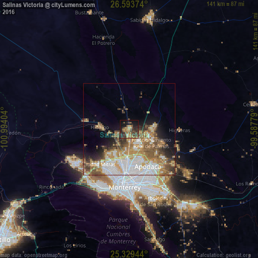
Analysis of Salinas Victoria night lights 2016
Square area 10x10 km:
 0.99%
0.99%90-99
0%80-89
3.97%70-79
6.35%60-69
11.11%50-59
8.13%40-49
10.71%30-39
9.72%20-29
15.08%10-19
22.82%0-9
11.11%Square area 50x50 km:
6.46%90-99
5.35%80-89
3.72%70-79
4.6%60-69
5.79%50-59
4.96%40-49
4.18%30-39
3.11%20-29
3.75%10-19
6.11%0-9
51.96%Clear (daylight) street map image can be seen on geolist.org.
Map coordinates:
26° 35' 37.5" North, 100° 59' 38.5" West
25° 57' 47.8" North, 100° 17' 27.3" West
25° 19' 46" North, 99° 35' 16" West
Some cities around Salinas Victoria sort by population:
• Fraccionamiento Real Palmas
14.7 km =9.1 mi,  116°
116°
• Hidalgo
16 km =9.9 mi,  273°
273°
• Ciénega de Flores
12.4 km =7.7 mi,  94°
94°
• Santa Rosa
16.9 km =10.5 mi,  155°
155°
• Carmen
7.9 km =4.9 mi,  247°
247°
• Emiliano Zapata
6 km =3.7 mi,  170°
170°
• Real del Sol
11.3 km =7 mi,  104°
104°
• Villas de Alcalá
11.8 km =7.3 mi, 116°
3988163 (p: 8,979)
Sources (retrieved 2019-11-25):
» Earth at Night: Flat Maps 2012, 2016