Hidalgo night lights from space
Night Light of Hidalgo (Nuevo León) from space (Mexico) Src. Average luminocity for 10x10km area is 15.2937% and for 50x50km: 21.8558%.
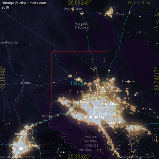
Analysis of Hidalgo night lights 2016
Square area 10x10 km:
 0%
0%90-99
0%80-89
2.78%70-79
1.59%60-69
3.57%50-59
5.56%40-49
4.76%30-39
0.2%20-29
1.39%10-19
2.78%0-9
77.38%Square area 50x50 km:
4.62%90-99
4.03%80-89
2.79%70-79
3.66%60-69
4.01%50-59
2.9%40-49
2.57%30-39
2.36%20-29
3.07%10-19
5.4%0-9
64.58%Clear (daylight) street map image can be seen on geolist.org.
Map coordinates:
26° 36' 8.9" North, 101° 9' 12.3" West
25° 58' 19.4" North, 100° 27' 1" West
25° 20' 17.7" North, 99° 44' 49.8" West
Some cities around Hidalgo sort by population:
• Ciudad General Escobedo
23.5 km =14.6 mi,  145°
145°
• García
23.2 km =14.4 mi,  219°
219°
• Parque Industrial Ciudad Mitras
20.4 km =12.7 mi,  179°
179°
• Mitras Poniente
22 km =13.7 mi,  173°
173°
• Carmen
9.5 km =5.9 mi,  114°
114°
• Salinas Victoria
16 km =9.9 mi,  93°
93°
• Emiliano Zapata
18.3 km =11.4 mi, 112°
• Valle de Lincoln
20.1 km =12.5 mi,  187°
187°
4022735 (p: 16,524)
Sources (retrieved 2019-11-25):
» Earth at Night: Flat Maps 2012, 2016