Rincón de Nicolás Romero (Cedros Tercera Manzana) night lights from space
Night Light of Rincón de Nicolás Romero (Cedros Tercera Manzana) (Michoacán) from space (Mexico) Src. Average luminocity for 10x10km area is 14.0888% and for 50x50km: 5.9557%.
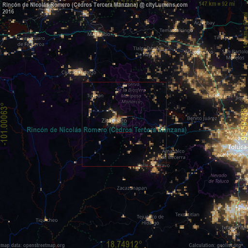
Analysis of Rincón de Nicolás Romero (Cedros Tercera Manzana) night lights 2016
Square area 10x10 km:
 0%
0%90-99
0.41%80-89
0%70-79
4.75%60-69
5.17%50-59
2.48%40-49
2.07%30-39
2.69%20-29
2.89%10-19
9.09%0-9
70.45%Square area 50x50 km:
0.02%90-99
0.17%80-89
0.91%70-79
0.84%60-69
0.92%50-59
0.83%40-49
1.84%30-39
1.6%20-29
1.28%10-19
3.65%0-9
87.95%Clear (daylight) street map image can be seen on geolist.org.
Map coordinates:
20° 4' 31.4" North, 101° 0' 2.3" West
19° 24' 49" North, 100° 17' 51" West
18° 44' 56.8" North, 99° 35' 39.8" West
Some cities around Rincón de Nicolás Romero (Cedros Tercera Manzana) sort by population:
• Heróica Zitácuaro
6.8 km =4.2 mi,  291°
291°
• Valle de Bravo
29.9 km =18.6 mi,  144°
144°
• Tuzantla
36.7 km =22.8 mi,  230°
230°
• Tuxpan
24.3 km =15.1 mi,  314°
314°
• Amanalco de Becerra
31.4 km =19.5 mi,  110°
110°
• San Nicolás Guadalupe
35.8 km =22.2 mi,  51°
51°
• Colorines
27.5 km =17.1 mi,  162°
162°
• Jungapeo de Juárez
21.3 km =13.2 mi,  283°
283°
8858222 (p: 6,213)
Sources (retrieved 2019-11-25):
» Earth at Night: Flat Maps 2012, 2016