Colorines night lights from space
Night Light of Colorines (México) from space (Mexico) Src. Average luminocity for 10x10km area is 15.0043% and for 50x50km: 4.6981%.
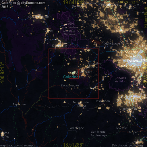
Analysis of Colorines night lights 2016
Square area 10x10 km:
 0%
0%90-99
0.65%80-89
5.19%70-79
1.08%60-69
1.73%50-59
1.08%40-49
1.73%30-39
5.19%20-29
3.25%10-19
3.25%0-9
76.84%Square area 50x50 km:
0%90-99
0.06%80-89
0.7%70-79
0.47%60-69
0.8%50-59
0.89%40-49
1.3%30-39
1.33%20-29
1.19%10-19
2.58%0-9
90.69%Clear (daylight) street map image can be seen on geolist.org.
Map coordinates:
19° 50' 27.7" North, 100° 55' 16.7" West
19° 10' 41.8" North, 100° 13' 5.4" West
18° 30' 46.3" North, 99° 30' 54.2" West
Some cities around Colorines sort by population:
• Heróica Zitácuaro
32.2 km =20 mi,  333°
333°
• Tejupilco de Hidalgo
31.2 km =19.4 mi,  167°
167°
• Valle de Bravo
9.3 km =5.8 mi,  78°
78°
• Tuzantla
36.7 km =22.8 mi,  274°
274°
• Villa Luvianos
34.8 km =21.6 mi,  213°
213°
• Villa Luvianos
29.9 km =18.6 mi,  196°
196°
• Rincón de Nicolás Romero (Cedros Tercera Manzana)
27.5 km =17.1 mi,  342°
342°
• Amanalco de Becerra
26.2 km =16.3 mi,  53°
53°
4013141 (p: 5,543)
Sources (retrieved 2019-11-25):
» Earth at Night: Flat Maps 2012, 2016