Petaquillas night lights from space
Night Light of Petaquillas (Guerrero) from space (Mexico) Src. Average luminocity for 10x10km area is 20.6364% and for 50x50km: 4.5938%.
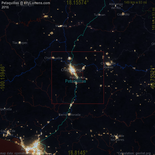
Analysis of Petaquillas night lights 2016
Square area 10x10 km:
 1.24%
1.24%90-99
1.86%80-89
3.51%70-79
3.31%60-69
4.96%50-59
0.83%40-49
3.93%30-39
1.65%20-29
3.93%10-19
19.42%0-9
55.37%Square area 50x50 km:
0.44%90-99
0.46%80-89
0.7%70-79
0.7%60-69
0.61%50-59
0.26%40-49
0.93%30-39
0.73%20-29
1.18%10-19
3.74%0-9
90.26%Clear (daylight) street map image can be seen on geolist.org.
Map coordinates:
18° 9' 20.7" North, 100° 9' 34.1" West
17° 29' 10.9" North, 99° 27' 22.8" West
16° 48' 52.2" North, 98° 45' 11.6" West
Some cities around Petaquillas sort by population:
• Chilpancingo
8.9 km =5.5 mi,  323°
323°
• Zumpango del Río
20.1 km =12.5 mi,  338°
338°
• Tixtla de Guerrero
10.9 km =6.8 mi,  34°
34°
• El Ocotito
27.4 km =17 mi,  193°
193°
• Atliaca
20.3 km =12.6 mi, 25°
• Quechultenango
24.1 km =15 mi,  109°
109°
• Mazatlán
5.6 km =3.5 mi, 189°
• Mochitlán
9.2 km =5.7 mi,  100°
100°
3521607 (p: 9,801)
Sources (retrieved 2019-11-25):
» Earth at Night: Flat Maps 2012, 2016