El Ocotito night lights from space
Night Light of El Ocotito (Guerrero) from space (Mexico) Src. Average luminocity for 10x10km area is 8.3595% and for 50x50km: 1.0439%.
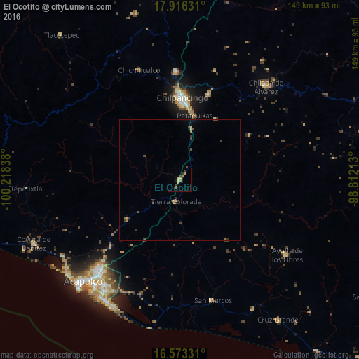
Analysis of El Ocotito night lights 2016
Square area 10x10 km:
 0%
0%90-99
0%80-89
2.48%70-79
2.89%60-69
1.24%50-59
0%40-49
2.48%30-39
1.24%20-29
0.41%10-19
0.83%0-9
88.43%Square area 50x50 km:
0%90-99
0%80-89
0.26%70-79
0.11%60-69
0.19%50-59
0.06%40-49
0.46%30-39
0.35%20-29
0.06%10-19
0.14%0-9
98.37%Clear (daylight) street map image can be seen on geolist.org.
Map coordinates:
17° 54' 58.7" North, 100° 13' 6.2" West
17° 14' 45.7" North, 99° 30' 54.9" West
16° 34' 23.9" North, 98° 48' 43.7" West
Some cities around El Ocotito sort by population:
• Chilpancingo
33.9 km =21.1 mi,  1°
1°
• Tixtla de Guerrero
37.8 km =23.5 mi,  19°
19°
• Tierra Colorada
9 km =5.6 mi,  188°
188°
• Petaquillas
27.4 km =17 mi,  13°
13°
• Xaltianguis
26.9 km =16.7 mi,  232°
232°
• Quechultenango
34.5 km =21.4 mi,  57°
57°
• Mazatlán
21.8 km =13.5 mi, 14°
• Mochitlán
29.4 km =18.3 mi,  31°
31°
3528601 (p: 6,882)
Sources (retrieved 2019-11-25):
» Earth at Night: Flat Maps 2012, 2016