Las Vigas de Ramírez night lights from space
Night Light of Las Vigas de Ramírez (Veracruz) from space (Mexico) Src. Average luminocity for 10x10km area is 5.5186% and for 50x50km: 10.6423%.
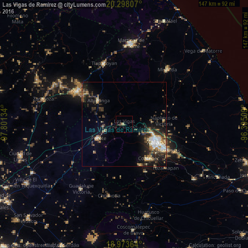
Analysis of Las Vigas de Ramírez night lights 2016
Square area 10x10 km:
 0%
0%90-99
0%80-89
1.24%70-79
0.83%60-69
1.24%50-59
0.83%40-49
1.86%30-39
1.03%20-29
0.83%10-19
1.65%0-9
90.5%Square area 50x50 km:
1.41%90-99
1.27%80-89
1.37%70-79
1.05%60-69
1.57%50-59
1.13%40-49
2.12%30-39
2.43%20-29
3.64%10-19
6.11%0-9
77.92%Clear (daylight) street map image can be seen on geolist.org.
Map coordinates:
20° 17' 53.1" North, 97° 48' 4.8" West
19° 38' 14" North, 97° 5' 53.6" West
18° 58' 25.1" North, 96° 23' 42.3" West
Some cities around Las Vigas de Ramírez sort by population:
• Xalapa de Enríquez
22.4 km =13.9 mi,  121°
121°
• Coatepec
25.1 km =15.6 mi,  145°
145°
• Perote
17.2 km =10.7 mi,  241°
241°
• Altotonga
21 km =13 mi,  312°
312°
• Banderilla
17.7 km =11 mi,  107°
107°
• Naolinco de Victoria
23.6 km =14.7 mi,  85°
85°
• Coacoatzintla
16.6 km =10.3 mi,  84°
84°
• Guadalupe Victoria
17.1 km =10.6 mi, 122°
3524580 (p: 9,684)
Sources (retrieved 2019-11-25):
» Earth at Night: Flat Maps 2012, 2016