La Negreta night lights from space
Night Light of La Negreta (Querétaro) from space (Mexico) Src. Average luminocity for 10x10km area is 72.7273% and for 50x50km: 35.5961%.
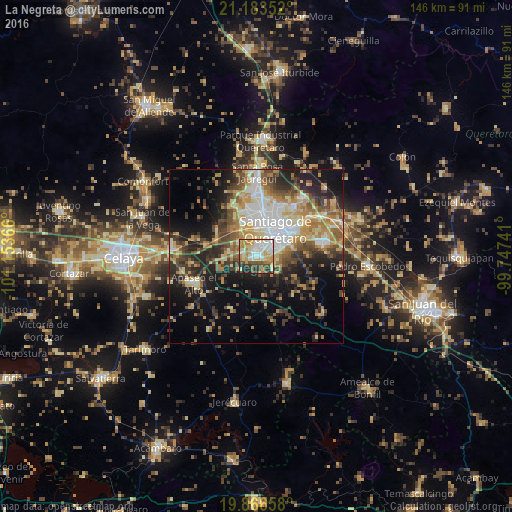
Analysis of La Negreta night lights 2016
Square area 10x10 km:
 16.67%
90-99
14.77%80-89
15.53%70-79
15.15%60-69
9.85%50-59
5.68%40-49
8.71%30-39
6.44%20-29
6.06%10-19
1.14%0-9
0%Square area 50x50 km:
5.55%90-99
4.78%80-89
5.8%70-79
6.11%60-69
5.6%50-59
4.28%40-49
6.39%30-39
5.87%20-29
8.33%10-19
13.54%0-9
33.78%Clear (daylight) street map image can be seen on geolist.org.
Map coordinates:
21° 11' 0.7" North, 101° 9' 13.2" West
20° 31' 35.3" North, 100° 27' 1.9" West
19° 51' 59.7" North, 99° 44' 50.7" West
Some cities around La Negreta sort by population:
• Santiago de Querétaro
9.4 km =5.8 mi,  43°
43°
• El Pueblito
2 km =1.2 mi, 40°
• San Jose de los Olvera
4.7 km =2.9 mi,  51°
51°
• Venceremos
6.1 km =3.8 mi,  63°
63°
• San José el Alto
15.8 km =9.8 mi,  26°
26°
• San Pedro Mártir
10.4 km =6.5 mi,  348°
348°
• La Cañada
15.3 km =9.5 mi, 53°
• Santa María Magdalena
7.8 km =4.8 mi,  2°
2°
4001188 (p: 8,100)
Sources (retrieved 2019-11-25):
» Earth at Night: Flat Maps 2012, 2016