La Cañada night lights from space
Night Light of La Cañada (Querétaro) from space (Mexico) Src. Average luminocity for 10x10km area is 84.9034% and for 50x50km: 39.1047%.
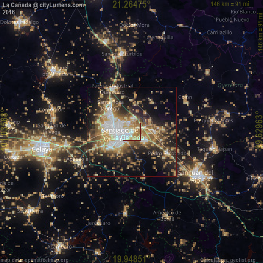
Analysis of La Cañada night lights 2016
Square area 10x10 km:
 21.59%
90-99
19.89%80-89
22.35%70-79
20.45%60-69
13.83%50-59
1.89%40-49
0%30-39
0%20-29
0%10-19
0%0-9
0%Square area 50x50 km:
5.7%90-99
5.03%80-89
6.48%70-79
7.04%60-69
6.16%50-59
4.89%40-49
7.53%30-39
6.16%20-29
9.8%10-19
15.77%0-9
25.43%Clear (daylight) street map image can be seen on geolist.org.
Map coordinates:
21° 15' 53.1" North, 101° 2' 9.2" West
20° 36' 29" North, 100° 19' 57.9" West
19° 56' 54.6" North, 99° 37' 46.7" West
Some cities around La Cañada sort by population:
• Santiago de Querétaro
6.2 km =3.9 mi,  248°
248°
• San Jose de los Olvera
10.5 km =6.5 mi,  234°
234°
• Venceremos
9.3 km =5.8 mi, 226°
• San José el Alto
7.2 km =4.5 mi,  314°
314°
• Santa María Magdalena
12 km =7.5 mi,  264°
264°
• La Pradera
5.7 km =3.5 mi,  350°
350°
• Amazcala
12.7 km =7.9 mi,  33°
33°
• Saldarriaga
4.7 km =2.9 mi,  61°
61°
4003211 (p: 10,506)
Sources (retrieved 2019-11-25):
» Earth at Night: Flat Maps 2012, 2016