El Castillo night lights from space
Night Light of El Castillo (Veracruz) from space (Mexico) Src. Average luminocity for 10x10km area is 56.3202% and for 50x50km: 10.5233%.
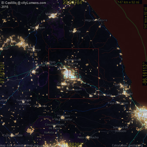
Analysis of El Castillo night lights 2016
Square area 10x10 km:
 13.02%
90-99
12.81%80-89
4.75%70-79
7.64%60-69
9.3%50-59
6.82%40-49
6.4%30-39
8.06%20-29
13.84%10-19
15.29%0-9
2.07%Square area 50x50 km:
1.4%90-99
1.36%80-89
1.18%70-79
1.19%60-69
1.46%50-59
1.23%40-49
2.18%30-39
2.33%20-29
3.44%10-19
6.25%0-9
77.99%Clear (daylight) street map image can be seen on geolist.org.
Map coordinates:
20° 12' 28.2" North, 97° 34' 2.6" West
19° 32' 47.8" North, 96° 51' 51.3" West
18° 52' 57.6" North, 96° 9' 40.1" West
Some cities around El Castillo sort by population:
• Xalapa de Enríquez
5.7 km =3.5 mi,  252°
252°
• Banderilla
9 km =5.6 mi,  301°
301°
• Naolinco de Victoria
12.1 km =7.5 mi,  355°
355°
• Colonia Santa Bárbara
5.2 km =3.2 mi,  196°
196°
• Jacarandas
5.8 km =3.6 mi,  168°
168°
• Coacoatzintla
14.1 km =8.8 mi,  325°
325°
• Lomas Verdes
5.4 km =3.4 mi,  208°
208°
• Guadalupe Victoria
10.1 km =6.3 mi,  275°
275°
3529243 (p: 5,154)
Sources (retrieved 2019-11-25):
» Earth at Night: Flat Maps 2012, 2016