Mitras Poniente night lights from space
Night Light of Mitras Poniente (Nuevo León) from space (Mexico) Src. Average luminocity for 10x10km area is 81.5076% and for 50x50km: 43.7498%.
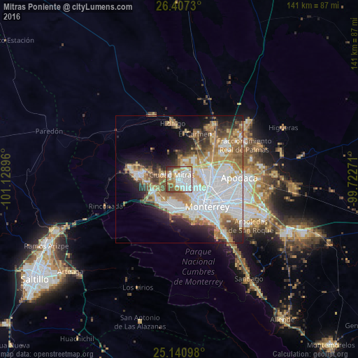
Analysis of Mitras Poniente night lights 2016
Square area 10x10 km:
 33.33%
90-99
20.27%80-89
5.49%70-79
9.47%60-69
11.74%50-59
8.71%40-49
6.82%30-39
2.84%20-29
1.33%10-19
0%0-9
0%Square area 50x50 km:
13.87%90-99
9.11%80-89
4.57%70-79
5.25%60-69
6.72%50-59
5.08%40-49
3.87%30-39
3.67%20-29
5.49%10-19
8.46%0-9
33.9%Clear (daylight) street map image can be seen on geolist.org.
Map coordinates:
26° 24' 26.3" North, 101° 7' 44.3" West
25° 46' 33" North, 100° 25' 33" West
25° 8' 27.5" North, 99° 43' 21.8" West
Some cities around Mitras Poniente sort by population:
• Monterrey
15.5 km =9.6 mi,  136°
136°
• San Nicolás de los Garza
12.9 km =8 mi,  107°
107°
• Ciudad General Escobedo
11.1 km =6.9 mi,  77°
77°
• Santa Catarina
11.9 km =7.4 mi,  195°
195°
• San Pedro Garza García
13 km =8.1 mi,  171°
171°
• García
17.8 km =11.1 mi,  283°
283°
• Parque Industrial Ciudad Mitras
2.6 km =1.6 mi,  302°
302°
• Valle de Lincoln
5.6 km =3.5 mi,  290°
290°
8858110 (p: 18,246)
Sources (retrieved 2019-11-25):
» Earth at Night: Flat Maps 2012, 2016