Cuauhtémoc night lights from space
Night Light of Cuauhtémoc (Tamaulipas) from space (Mexico) Src. Average luminocity for 10x10km area is 3.6288% and for 50x50km: 4.1157%.
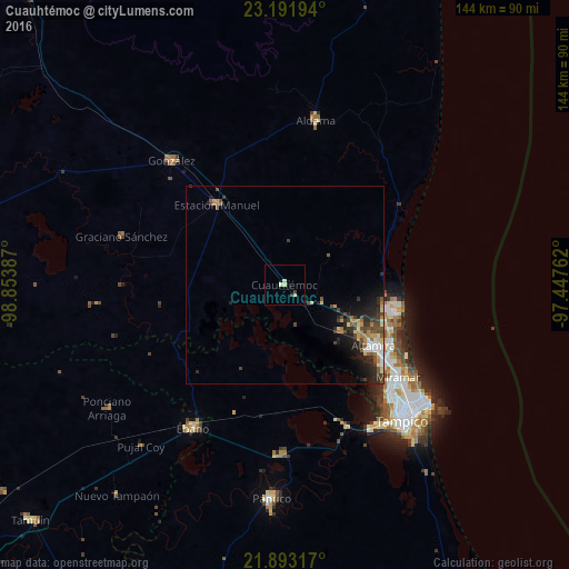
Analysis of Cuauhtémoc night lights 2016
Square area 10x10 km:
 0%
0%90-99
0.57%80-89
2.46%70-79
0%60-69
0%50-59
0%40-49
0%30-39
1.52%20-29
0%10-19
0%0-9
95.45%Square area 50x50 km:
0.24%90-99
0.62%80-89
0.54%70-79
0.51%60-69
0.64%50-59
0.53%40-49
0.96%30-39
0.88%20-29
1.7%10-19
2.31%0-9
91.08%Clear (daylight) street map image can be seen on geolist.org.
Map coordinates:
23° 11' 31" North, 98° 51' 13.9" West
22° 32' 38.7" North, 98° 9' 2.7" West
21° 53' 35.4" North, 97° 26' 51.4" West
Some cities around Cuauhtémoc sort by population:
• Tampico
40.2 km =25 mi,  135°
135°
• Miramar
32.8 km =20.4 mi,  128°
128°
• Altamira
27.6 km =17.1 mi, 127°
• Ébano
43.1 km =26.8 mi,  212°
212°
• Aldama
42.7 km =26.5 mi,  10°
10°
• Ursulo Galván
26.9 km =16.7 mi,  319°
319°
• González
42.4 km =26.3 mi, 318°
• Moralillo
43.1 km =26.8 mi,  145°
145°
3482886 (p: 5,563)
Sources (retrieved 2019-11-25):
» Earth at Night: Flat Maps 2012, 2016