Cruz Grande night lights from space
Night Light of Cruz Grande (Guerrero) from space (Mexico) Src. Average luminocity for 10x10km area is 6.0087% and for 50x50km: 0.8788%.
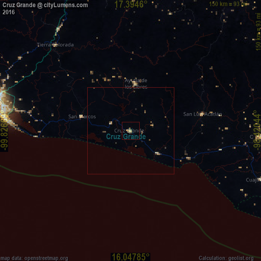
Analysis of Cruz Grande night lights 2016
Square area 10x10 km:
 0%
0%90-99
0%80-89
1.52%70-79
2.16%60-69
0.65%50-59
2.6%40-49
0%30-39
0.22%20-29
1.08%10-19
0.43%0-9
91.34%Square area 50x50 km:
0%90-99
0.01%80-89
0.18%70-79
0.19%60-69
0.09%50-59
0.17%40-49
0.32%30-39
0.18%20-29
0.23%10-19
0.18%0-9
98.46%Clear (daylight) street map image can be seen on geolist.org.
Map coordinates:
17° 23' 40.6" North, 99° 49' 36.1" West
16° 43' 20.7" North, 99° 7' 24.8" West
16° 2' 52.3" North, 98° 25' 13.6" West
Some cities around Cruz Grande sort by population:
• Ayutla de los Libres
27 km =16.8 mi,  6°
6°
• San Marcos
29.5 km =18.3 mi,  286°
286°
• Tierra Colorada
65.4 km =40.6 mi,  318°
318°
• San Luis Acatlán
42.6 km =26.5 mi,  76°
76°
• El Ocotito
71.6 km =44.5 mi, 324°
• Copala
20.1 km =12.5 mi,  129°
129°
• Marquelia
36.1 km =22.4 mi,  115°
115°
• Tres Palos
70.7 km =43.9 mi,  279°
279°
3530066 (p: 11,783)
Sources (retrieved 2019-11-25):
» Earth at Night: Flat Maps 2012, 2016