Tres Palos night lights from space
Night Light of Tres Palos (Guerrero) from space (Mexico) Src. Average luminocity for 10x10km area is 58.316% and for 50x50km: 12.3585%.
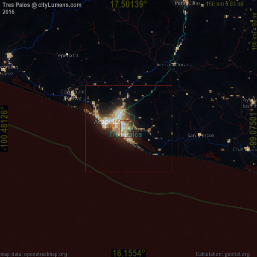
Analysis of Tres Palos night lights 2016
Square area 10x10 km:
 4.76%
4.76%90-99
12.34%80-89
13.85%70-79
13.85%60-69
6.49%50-59
8.23%40-49
7.36%30-39
7.36%20-29
13.42%10-19
12.34%0-9
0%Square area 50x50 km:
1.05%90-99
1.73%80-89
2.37%70-79
2.27%60-69
1.8%50-59
1.39%40-49
1.99%30-39
1.82%20-29
3.2%10-19
7.18%0-9
75.21%Clear (daylight) street map image can be seen on geolist.org.
Map coordinates:
17° 30' 5" North, 100° 28' 52.5" West
16° 49' 46.5" North, 99° 46' 41.3" West
16° 9' 19.4" North, 99° 4' 30" West
Some cities around Tres Palos sort by population:
• Acapulco de Juárez
14.1 km =8.8 mi,  279°
279°
• Coyuca de Benítez
38.4 km =23.9 mi,  301°
301°
• San Marcos
41.5 km =25.8 mi,  94°
94°
• Tierra Colorada
45.9 km =28.5 mi,  35°
35°
• Xaltianguis
30.6 km =19 mi,  12°
12°
• El Ocotito
54.1 km =33.6 mi,  31°
31°
• Kilómetro 30
18.7 km =11.6 mi,  359°
359°
• Bajos del Ejido
25.2 km =15.7 mi,  305°
305°
3821726 (p: 5,001)
Sources (retrieved 2019-11-25):
» Earth at Night: Flat Maps 2012, 2016