Cabezas night lights from space
Night Light of Cabezas (Veracruz) from space (Mexico) Src. Average luminocity for 10x10km area is 30.3781% and for 50x50km: 10.1278%.
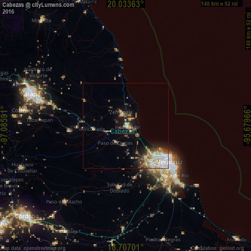
Analysis of Cabezas night lights 2016
Square area 10x10 km:
 0.41%
0.41%90-99
5.37%80-89
6.2%70-79
3.72%60-69
3.1%50-59
3.1%40-49
7.23%30-39
4.75%20-29
9.5%10-19
37.4%0-9
19.21%Square area 50x50 km:
1.78%90-99
1.81%80-89
1.19%70-79
1.28%60-69
1.31%50-59
1.18%40-49
1.64%30-39
1.61%20-29
1.86%10-19
4.77%0-9
81.59%Clear (daylight) street map image can be seen on geolist.org.
Map coordinates:
20° 2' 1.1" North, 97° 5' 9.3" West
19° 22' 18" North, 96° 22' 58" West
18° 42' 25.2" North, 95° 40' 46.8" West
Some cities around Cabezas sort by population:
• Valente Diaz
29 km =18 mi,  142°
142°
• José Cardel
1.4 km =0.9 mi,  105°
105°
• Las Amapolas
31.2 km =19.4 mi, 141°
• Fraccionamiento Geovillas los Pinos
23.8 km =14.8 mi, 136°
• Villa Zempoala
8.5 km =5.3 mi,  342°
342°
• Rinconada
19.3 km =12 mi,  264°
264°
• Paso de Ovejas
11.4 km =7.1 mi,  211°
211°
• Úrsulo Galván
4.4 km =2.7 mi,  31°
31°
3823333 (p: 6,167)
Sources (retrieved 2019-11-25):
» Earth at Night: Flat Maps 2012, 2016