Paso de Ovejas night lights from space
Night Light of Paso de Ovejas (Veracruz) from space (Mexico) Src. Average luminocity for 10x10km area is 7.6277% and for 50x50km: 9.642%.
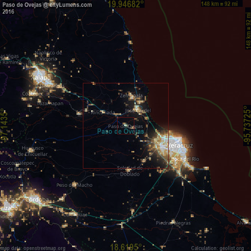
Analysis of Paso de Ovejas night lights 2016
Square area 10x10 km:
 0%
0%90-99
0.87%80-89
0.87%70-79
0.22%60-69
1.95%50-59
1.3%40-49
1.52%30-39
2.16%20-29
1.73%10-19
0.43%0-9
88.96%Square area 50x50 km:
0.62%90-99
1.36%80-89
1.3%70-79
1.3%60-69
1.32%50-59
1.41%40-49
2.16%30-39
2.16%20-29
2.54%10-19
5.63%0-9
80.19%Clear (daylight) street map image can be seen on geolist.org.
Map coordinates:
19° 56' 48.6" North, 97° 8' 36.6" West
19° 17' 4.2" North, 96° 26' 25.3" West
18° 37' 10.2" North, 95° 44' 14.1" West
Some cities around Paso de Ovejas sort by population:
• José Cardel
11.9 km =7.4 mi,  38°
38°
• Fraccionamiento Geovillas los Pinos
23.7 km =14.7 mi,  108°
108°
• Soledad de Doblado
26.6 km =16.5 mi,  175°
175°
• Villa Zempoala
18.1 km =11.2 mi,  10°
10°
• Rinconada
15.3 km =9.5 mi,  300°
300°
• Cabezas
11.4 km =7.1 mi,  31°
31°
• Manlio Fabio Altamirano
23.9 km =14.9 mi,  152°
152°
• Úrsulo Galván
15.8 km =9.8 mi, 31°
3521825 (p: 7,468)
Sources (retrieved 2019-11-25):
» Earth at Night: Flat Maps 2012, 2016