Anenecuilco night lights from space
Night Light of Anenecuilco (Morelos) from space (Mexico) Src. Average luminocity for 10x10km area is 43.2252% and for 50x50km: 33.3709%.
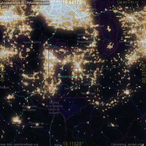
Analysis of Anenecuilco night lights 2016
Square area 10x10 km:
 3.1%
3.1%90-99
4.34%80-89
9.5%70-79
6.82%60-69
9.09%50-59
5.17%40-49
12.6%30-39
6.61%20-29
10.74%10-19
22.11%0-9
9.92%Square area 50x50 km:
1.59%90-99
3.1%80-89
6.47%70-79
6.85%60-69
7.01%50-59
4.08%40-49
7.93%30-39
6.28%20-29
10.01%10-19
17.09%0-9
29.61%Clear (daylight) street map image can be seen on geolist.org.
Map coordinates:
19° 26' 30.3" North, 99° 41' 31.9" West
18° 46' 38.6" North, 98° 59' 20.7" West
18° 6' 37.4" North, 98° 17' 9.4" West
Some cities around Anenecuilco sort by population:
• Cuautla
6.8 km =4.2 mi,  56°
56°
• Yautepec
14.2 km =8.8 mi,  324°
324°
• Juan Morales
8 km =5 mi, 61°
• San Pedro Apatlaco
3.5 km =2.2 mi, 60°
• Cocoyoc
11.9 km =7.4 mi,  3°
3°
• Tenextepango
6.3 km =3.9 mi,  148°
148°
• Ciudad Ayala
1.4 km =0.9 mi, 148°
• Los Arcos
12.8 km =8 mi,  343°
343°
3532858 (p: 10,773)
Sources (retrieved 2019-11-25):
» Earth at Night: Flat Maps 2012, 2016