Unidad Minera 11 de Julio night lights from space
Night Light of Unidad Minera 11 de Julio (Hidalgo) from space (Mexico) Src. Average luminocity for 10x10km area is 79.6409% and for 50x50km: 22.0888%.
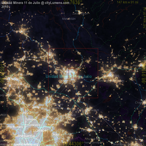
Analysis of Unidad Minera 11 de Julio night lights 2016
Square area 10x10 km:
 20.44%
90-99
22.22%80-89
13.69%70-79
16.87%60-69
8.33%50-59
5.16%40-49
11.11%30-39
1.59%20-29
0.6%10-19
0%0-9
0%Square area 50x50 km:
1.83%90-99
2.01%80-89
3.52%70-79
3.44%60-69
4.35%50-59
2.4%40-49
4.39%30-39
4.25%20-29
6.29%10-19
16.13%0-9
51.38%Clear (daylight) street map image can be seen on geolist.org.
Map coordinates:
20° 45' 49" North, 99° 25' 33.3" West
20° 6' 17" North, 98° 43' 22" West
19° 26' 35" North, 98° 1' 10.8" West
Some cities around Unidad Minera 11 de Julio sort by population:
• Pachuca de Soto
1.7 km =1.1 mi,  321°
321°
• La Providencia Siglo XXI
4.5 km =2.8 mi,  172°
172°
• Mineral del Monte
6.3 km =3.9 mi,  53°
53°
• San Agustín Tlaxiaca
17.1 km =10.6 mi,  273°
273°
• Acayuca
15.2 km =9.4 mi,  234°
234°
• Campestre Villas del Álamo
1.7 km =1.1 mi,  101°
101°
• Pachuquilla
4.7 km =2.9 mi,  143°
143°
• Los Tuzos
6.7 km =4.2 mi,  211°
211°
8858244 (p: 5,692)
Sources (retrieved 2019-11-25):
» Earth at Night: Flat Maps 2012, 2016