Зуунмод night lights from space
Night Light of Зуунмод (Central Aimak) from space (Mongolia) Src. Average luminocity for 10x10km area is 2.619% and for 50x50km: 6.8152%.
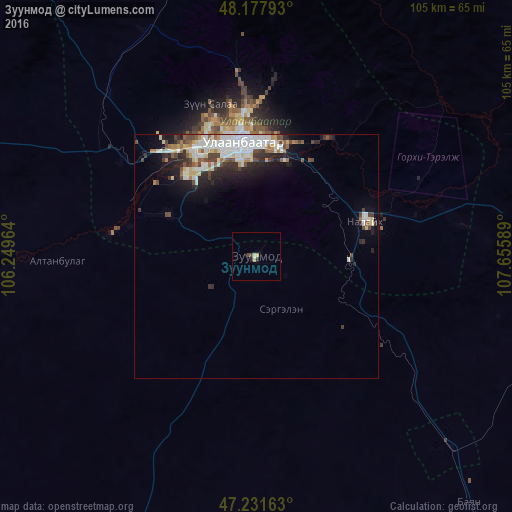
Analysis of Зуунмод night lights 2016
Square area 10x10 km:
 0%
0%90-99
0.6%80-89
0.74%70-79
0.45%60-69
0%50-59
0%40-49
0.6%30-39
0.6%20-29
1.19%10-19
0.15%0-9
95.68%Square area 50x50 km:
1.82%90-99
1.42%80-89
0.64%70-79
0.46%60-69
0.63%50-59
0.6%40-49
1.14%30-39
0.84%20-29
1.85%10-19
2.9%0-9
87.71%Clear (daylight) street map image can be seen on geolist.org.
Map coordinates:
48° 10' 40.5" North, 106° 14' 58.7" East
47° 42' 24.9" North, 106° 57' 9.9" East
47° 13' 53.9" North, 107° 39' 21.2" East
Some cities around Зуунмод sort by population:
• Ulan Bator
22.9 km =14.2 mi,  346°
346°
• Erdenet
258.2 km =160.4 mi,  304°
304°
• Darhan
211.9 km =131.7 mi,  339°
339°
• Dzüünharaa
132.5 km =82.3 mi, 343°
• Bulgan
281.3 km =174.8 mi, 295°
• Mandalgovi
222.4 km =138.2 mi,  193°
193°
• Dzuunmod
0 km =0 mi,  53°
53°
• Choyr
183.8 km =114.2 mi,  144°
144°
7648817 (p: 17,630)
Sources (retrieved 2019-11-25):
» Earth at Night: Flat Maps 2012, 2016