Struga night lights from space
Night Light of Struga from space (North Macedonia) Src. Average luminocity for 10x10km area is 9.5974% and for 50x50km: 1.8113%.
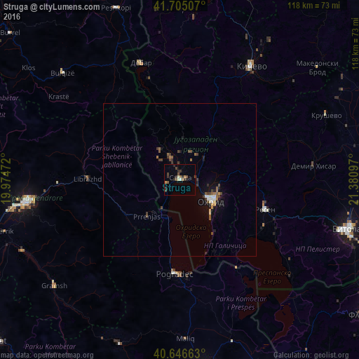
Analysis of Struga night lights 2016
Square area 10x10 km:
 0.32%
0.32%90-99
0.81%80-89
0.81%70-79
0.81%60-69
0.65%50-59
2.6%40-49
1.79%30-39
4.06%20-29
3.57%10-19
0.16%0-9
84.42%Square area 50x50 km:
0.12%90-99
0.21%80-89
0.09%70-79
0.15%60-69
0.2%50-59
0.42%40-49
0.44%30-39
0.5%20-29
0.32%10-19
0.96%0-9
96.59%Clear (daylight) street map image can be seen on geolist.org.
Map coordinates:
41° 42' 18.3" North, 19° 58' 29" East
41° 10' 40.8" North, 20° 40' 40.2" East
40° 38' 47.9" North, 21° 22' 51.5" East
Some cities around Struga sort by population:
• Ohrid
12.4 km =7.7 mi,  123°
123°
• Resen
29.6 km =18.4 mi,  109°
109°
• Librazhd-Qendër, AL
28.7 km =17.8 mi,  274°
274°
• Labunista
12.2 km =7.6 mi,  325°
325°
• Velesta
7.5 km =4.7 mi,  337°
337°
• Delogožda
9.6 km =6 mi,  22°
22°
• Belčišta
18.8 km =11.7 mi,  42°
42°
• Vevčani
9.9 km =6.2 mi,  314°
314°
785387 (p: 37,387)
Sources (retrieved 2019-11-25):
» Earth at Night: Flat Maps 2012, 2016