Džepčište night lights from space
Night Light of Džepčište (Tetovo) from space (North Macedonia) Src. Average luminocity for 10x10km area is 17.5016% and for 50x50km: 3.5484%.
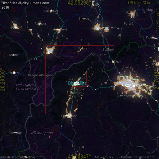
Analysis of Džepčište night lights 2016
Square area 10x10 km:
 2.54%
2.54%90-99
5.08%80-89
0.79%70-79
1.43%60-69
1.59%50-59
2.54%40-49
1.9%30-39
3.49%20-29
0.32%10-19
12.86%0-9
67.46%Square area 50x50 km:
0.25%90-99
0.46%80-89
0.25%70-79
0.42%60-69
0.49%50-59
0.72%40-49
0.63%30-39
0.66%20-29
0.54%10-19
2.87%0-9
92.7%Clear (daylight) street map image can be seen on geolist.org.
Map coordinates:
42° 33' 10.7" North, 20° 17' 42.2" East
42° 1' 58.3" North, 20° 59' 53.4" East
41° 30' 30.5" North, 21° 42' 4.7" East
Some cities around Džepčište sort by population:
• Tetovo
3.4 km =2.1 mi,  220°
220°
• Zelino
8 km =5 mi,  136°
136°
• Tearce
6.7 km =4.2 mi,  42°
42°
• Brvenica
7.4 km =4.6 mi,  191°
191°
• Kamenjane
11.3 km =7 mi,  210°
210°
• Bogovinje
14 km =8.7 mi, 209°
• Šipkovica
6.8 km =4.2 mi,  271°
271°
• Jegunovce
11.3 km =7 mi,  67°
67°
790857 (p: 8,166)
Sources (retrieved 2019-11-25):
» Earth at Night: Flat Maps 2012, 2016