Criuleni night lights from space
Night Light of Criuleni from space (Moldova) Src. Average luminocity for 10x10km area is 4.5015% and for 50x50km: 4.8002%.
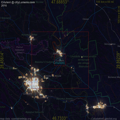
Analysis of Criuleni night lights 2016
Square area 10x10 km:
 0%
0%90-99
0%80-89
1.19%70-79
0.3%60-69
1.49%50-59
0%40-49
0.6%30-39
0%20-29
0.6%10-19
2.68%0-9
93.15%Square area 50x50 km:
0.96%90-99
1.27%80-89
0.54%70-79
0.35%60-69
0.49%50-59
0.32%40-49
0.36%30-39
0.78%20-29
1.26%10-19
2.04%0-9
91.63%Clear (daylight) street map image can be seen on geolist.org.
Map coordinates:
47° 41' 18.7" North, 28° 27' 22.1" East
47° 12' 47.1" North, 29° 9' 33.3" East
46° 43' 59.9" North, 29° 51' 44.6" East
Some cities around Criuleni sort by population:
• Orhei
31.7 km =19.7 mi,  307°
307°
• Dubăsari
5.9 km =3.7 mi,  5°
5°
• Hryhoriopol
12.5 km =7.8 mi,  121°
121°
• Cricova
24 km =14.9 mi,  249°
249°
• Ciorescu
22.4 km =13.9 mi, 245°
• Stăuceni
25.6 km =15.9 mi,  239°
239°
• Vadul lui Vodă
15.1 km =9.4 mi,  204°
204°
• Cocieri
10.3 km =6.4 mi,  342°
342°
618403 (p: 6,932)
Sources (retrieved 2019-11-25):
» Earth at Night: Flat Maps 2012, 2016