Masallātah night lights from space
Night Light of Masallātah (Al Marqab) from space (Libya) Src. Average luminocity for 10x10km area is 29.472% and for 50x50km: 19.7167%.
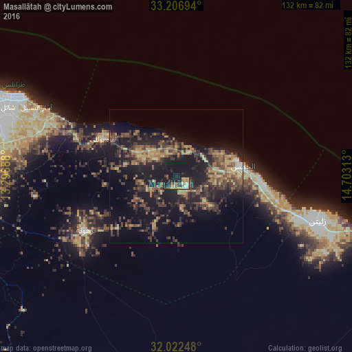

Analysis of Masallātah night lights 2016
Square area 10x10 km:
 1.75%
1.75%90-99
1.75%80-89
7.17%70-79
2.97%60-69
4.02%50-59
3.5%40-49
5.24%30-39
3.15%20-29
6.47%10-19
62.24%0-9
1.75%Square area 50x50 km:
0.27%90-99
0.47%80-89
3.42%70-79
2.43%60-69
3.33%50-59
3.74%40-49
4.86%30-39
6.7%20-29
6.91%10-19
20.72%0-9
47.14%Clear (daylight) street map image can be seen on geolist.org.
Map coordinates:
33° 12' 25" North, 13° 17' 48.8" East
32° 37' 0" North, 14° 0' 0" East
32° 1' 20.9" North, 14° 42' 11.3" East
Some cities around Masallātah sort by population:
• Tripoli
81.7 km =50.8 mi,  291°
291°
• Tarhuna
39.9 km =24.8 mi,  239°
239°
• Al Khums
24.8 km =15.4 mi,  81°
81°
• Zliten
55.8 km =34.7 mi,  107°
107°
• Tagiura
67.5 km =41.9 mi,  295°
295°
• Gharyan
104.4 km =64.9 mi, 241°
• Bani Walid
96.9 km =60.2 mi,  180°
180°
• Al ‘Azīzīyah
92.5 km =57.5 mi,  264°
264°
2215163 (p: 23,702)
Sources (retrieved 2019-11-25):
» Earth at Night: Flat Maps 2012, 2016