Hamhŭng night lights from space
Night Light of Hamhŭng (Hamgyŏng-namdo) from space (North Korea) Src. Average luminocity for 10x10km area is 1.5918% and for 50x50km: 0.1395%.
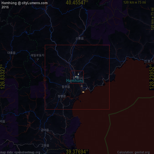
Analysis of Hamhŭng night lights 2016
Square area 10x10 km:
 0%
0%90-99
0%80-89
0.68%70-79
0%60-69
0%50-59
0%40-49
0.68%30-39
0%20-29
1.36%10-19
1.36%0-9
95.92%Square area 50x50 km:
0%90-99
0%80-89
0.06%70-79
0.02%60-69
0%50-59
0%40-49
0.03%30-39
0.03%20-29
0.11%10-19
0.07%0-9
99.68%Clear (daylight) street map image can be seen on geolist.org.
Map coordinates:
40° 27' 19.7" North, 126° 49' 59.8" East
39° 55' 6" North, 127° 32' 11" East
39° 22' 37" North, 128° 14' 22.3" East
Some cities around Hamhŭng sort by population:
• Hŭngnam
11.9 km =7.4 mi,  143°
143°
• Wŏnsan
85.5 km =53.1 mi,  185°
185°
• Yuktae-dong
54.4 km =33.8 mi,  77°
77°
• Hongwŏn
37.7 km =23.4 mi,  71°
71°
• Yŏnggwang-ŭp
13.1 km =8.1 mi,  327°
327°
• Kowŏn-ŭp
59 km =36.7 mi,  205°
205°
• Samho-rodongjagu
28.7 km =17.8 mi, 83°
• Sinsang-ni
31.8 km =19.8 mi,  200°
200°
1877449 (p: 559,056)
Sources (retrieved 2019-11-25):
» NASA, Earths city lights 1995
» NASA city lights 2003
» Earth at Night: Flat Maps 2012, 2016