Kerben night lights from space
Night Light of Kerben (Jalal-Abad) from space (Kyrgyzstan) Src. Average luminocity for 10x10km area is 11.0731% and for 50x50km: 2.2438%.
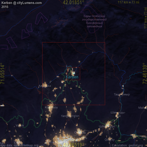
Analysis of Kerben night lights 2016
Square area 10x10 km:
 0.51%
0.51%90-99
0.68%80-89
1.19%70-79
1.02%60-69
1.36%50-59
4.25%40-49
2.21%30-39
3.74%20-29
1.7%10-19
0%0-9
83.33%Square area 50x50 km:
0.03%90-99
0.04%80-89
0.07%70-79
0.21%60-69
0.34%50-59
0.83%40-49
0.56%30-39
0.87%20-29
0.76%10-19
0.35%0-9
95.93%Clear (daylight) street map image can be seen on geolist.org.
Map coordinates:
42° 1' 6.6" North, 71° 3' 18.5" East
41° 29' 38.4" North, 71° 45' 29.7" East
40° 57' 54.7" North, 72° 27' 41" East
Some cities around Kerben sort by population:
• Namangan, UZ
55.6 km =34.5 mi,  187°
187°
• Chortoq, UZ
47.5 km =29.5 mi,  173°
173°
• Kosonsoy, UZ
32.4 km =20.1 mi,  212°
212°
• Uchqŭrghon Shahri, UZ
50.1 km =31.1 mi,  147°
147°
• Uychi, UZ
48 km =29.8 mi,  163°
163°
• Yangiqo‘rg‘on, UZ
33.4 km =20.8 mi,  184°
184°
• To‘rqao‘rg‘on, UZ
58.7 km =36.5 mi,  200°
200°
• Tash-Kumyr
41.6 km =25.8 mi,  113°
113°
1528052 (p: 14,141)
Sources (retrieved 2019-11-25):
» Earth at Night: Flat Maps 2012, 2016