Hayes night lights from space
Night Light of Hayes (Clarendon) from space (Jamaica) Src. Average luminocity for 10x10km area is 25.0909% and for 50x50km: 9.5798%.
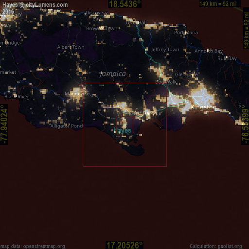
Analysis of Hayes night lights 2016
Square area 10x10 km:
 0.22%
0.22%90-99
1.52%80-89
4.11%70-79
5.19%60-69
5.41%50-59
2.81%40-49
3.25%30-39
2.16%20-29
5.63%10-19
44.37%0-9
25.32%Square area 50x50 km:
0.16%90-99
0.65%80-89
1.87%70-79
1.56%60-69
1.23%50-59
1.1%40-49
1.61%30-39
1.71%20-29
3.34%10-19
11.04%0-9
75.74%Clear (daylight) street map image can be seen on geolist.org.
Map coordinates:
18° 32' 37" North, 77° 56' 24.9" West
17° 52' 32.5" North, 77° 14' 13.6" West
17° 12' 18.9" North, 76° 32' 2.4" West
Some cities around Hayes sort by population:
• Spanish Town
32.2 km =20 mi,  66°
66°
• Mandeville
34 km =21.1 mi,  302°
302°
• May Pen
9.9 km =6.2 mi,  355°
355°
• Old Harbour
15.4 km =9.6 mi,  61°
61°
• Old Harbour Bay
15.3 km =9.5 mi,  75°
75°
• Porus
25.6 km =15.9 mi,  313°
313°
• Lionel Town
7.3 km =4.5 mi,  182°
182°
• Point Hill
27.5 km =17.1 mi,  29°
29°
3490106 (p: 9,701)
Sources (retrieved 2019-11-25):
» Earth at Night: Flat Maps 2012, 2016