Vill'Albese night lights from space
Night Light of Vill'Albese (Lombardy) from space (Italy) Src. Average luminocity for 10x10km area is 61.2634% and for 50x50km: 52.0517%.
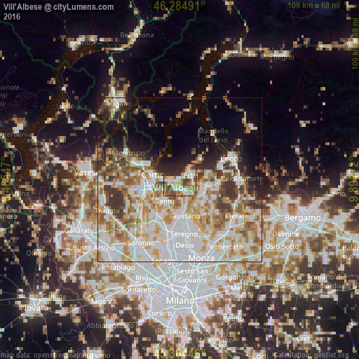
Analysis of Vill'Albese night lights 2016
Square area 10x10 km:
 8.48%
8.48%90-99
15.18%80-89
11.31%70-79
6.55%60-69
11.46%50-59
10.12%40-49
9.97%30-39
4.91%20-29
15.18%10-19
6.85%0-9
0%Square area 50x50 km:
15.06%90-99
12.42%80-89
5.69%70-79
7.29%60-69
7.19%50-59
5.51%40-49
4.65%30-39
5.85%20-29
4.56%10-19
8.14%0-9
23.64%Clear (daylight) street map image can be seen on geolist.org.
Map coordinates:
46° 17' 5.7" North, 8° 29' 7.7" East
45° 47' 48.6" North, 9° 11' 18.9" East
45° 18' 16.1" North, 9° 53' 30.2" East
Some cities around Vill'Albese sort by population:
• Como
8.3 km =5.2 mi,  278°
278°
• Cantù
7.7 km =4.8 mi,  215°
215°
• Erba
3.2 km =2 mi,  65°
65°
• Inverigo
6.9 km =4.3 mi,  160°
160°
• Albavilla
0.5 km =0.3 mi,  325°
325°
• Tavernerio
3.7 km =2.3 mi, 276°
• Lipomo
5.3 km =3.3 mi,  265°
265°
• Capiago-Intimiano-Olmeda
5.7 km =3.5 mi,  236°
236°
8948763 (p: 6,242)
Sources (retrieved 2019-11-25):
» Earth at Night: Flat Maps 2012, 2016