Inverigo night lights from space
Night Light of Inverigo (Lombardy) from space (Italy) Src. Average luminocity for 10x10km area is 80.4045% and for 50x50km: 61.218%.
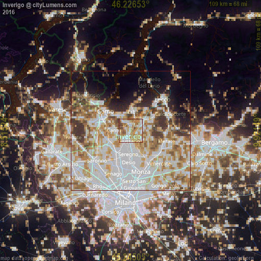
Analysis of Inverigo night lights 2016
Square area 10x10 km:
 17.88%
90-99
19.85%80-89
14.09%70-79
19.39%60-69
17.58%50-59
6.36%40-49
4.7%30-39
0.15%20-29
0%10-19
0%0-9
0%Square area 50x50 km:
20.89%90-99
15.16%80-89
6.25%70-79
7.95%60-69
7.86%50-59
5.77%40-49
4.55%30-39
5.12%20-29
3.86%10-19
7.05%0-9
15.55%Clear (daylight) street map image can be seen on geolist.org.
Map coordinates:
46° 13' 35.5" North, 8° 30' 54.9" East
45° 44' 16.6" North, 9° 13' 6.1" East
45° 14' 42.2" North, 9° 55' 17.4" East
Some cities around Inverigo sort by population:
• Cantù
6.8 km =4.2 mi,  272°
272°
• Giussano
4.3 km =2.7 mi,  189°
189°
• Mariano Comense
5.4 km =3.4 mi,  211°
211°
• Carate Brianza
7.1 km =4.4 mi,  168°
168°
• Verano Brianza
5.5 km =3.4 mi, 174°
• Besana in Brianza
7.1 km =4.4 mi,  123°
123°
• Vill'Albese
6.9 km =4.3 mi,  340°
340°
• Carugo
3.7 km =2.3 mi, 207°
3175497 (p: 8,475)
Sources (retrieved 2019-11-25):
» Earth at Night: Flat Maps 2012, 2016