Capiago-Intimiano-Olmeda night lights from space
Night Light of Capiago-Intimiano-Olmeda (Lombardy) from space (Italy) Src. Average luminocity for 10x10km area is 74.7159% and for 50x50km: 58.2066%.
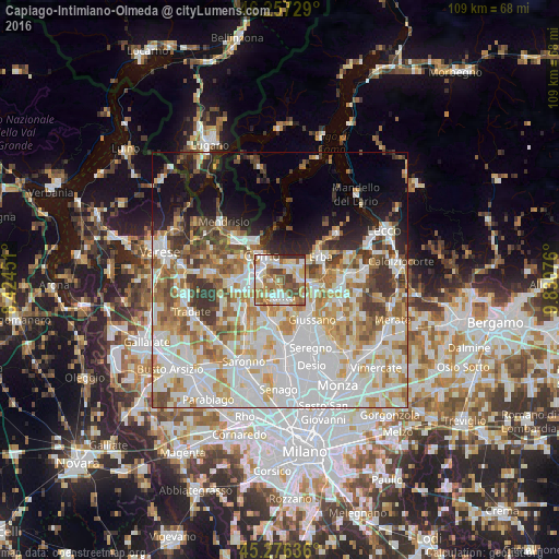
Analysis of Capiago-Intimiano-Olmeda night lights 2016
Square area 10x10 km:
 14.44%
90-99
20.79%80-89
13.02%70-79
10.79%60-69
12.38%50-59
11.43%40-49
11.27%30-39
2.7%20-29
3.17%10-19
0%0-9
0%Square area 50x50 km:
18.18%90-99
14.87%80-89
6.01%70-79
7.78%60-69
7.56%50-59
5.63%40-49
4.95%30-39
5.39%20-29
4.44%10-19
7.83%0-9
17.36%Clear (daylight) street map image can be seen on geolist.org.
Map coordinates:
46° 15' 26.2" North, 8° 25' 28.2" East
45° 46' 8.3" North, 9° 7' 39.5" East
45° 16' 34.9" North, 9° 49' 50.7" East
Some cities around Capiago-Intimiano-Olmeda sort by population:
• Como
5.6 km =3.5 mi,  321°
321°
• Cantù
3.1 km =1.9 mi,  175°
175°
• Inverigo
7.8 km =4.8 mi,  116°
116°
• Fino Mornasco
6.7 km =4.2 mi,  244°
244°
• Vill'Albese
5.7 km =3.5 mi,  56°
56°
• Albavilla
5.7 km =3.5 mi,  51°
51°
• Tavernerio
3.7 km =2.3 mi,  15°
15°
• Lipomo
2.7 km =1.7 mi,  347°
347°
6535115 (p: 5,270)
Sources (retrieved 2019-11-25):
» Earth at Night: Flat Maps 2012, 2016