Vibo Valentia night lights from space
Night Light of Vibo Valentia (Calabria) from space (Italy) Src. Average luminocity for 10x10km area is 44.0816% and for 50x50km: 11.9345%.
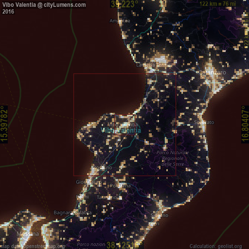
Analysis of Vibo Valentia night lights 2016
Square area 10x10 km:
 3.06%
3.06%90-99
8.5%80-89
9.35%70-79
6.63%60-69
6.12%50-59
3.57%40-49
4.25%30-39
10.88%20-29
23.13%10-19
21.94%0-9
2.55%Square area 50x50 km:
0.45%90-99
1.08%80-89
1.99%70-79
1.65%60-69
1.52%50-59
1.44%40-49
1.31%30-39
2.52%20-29
3.15%10-19
12.94%0-9
71.96%Clear (daylight) street map image can be seen on geolist.org.
Map coordinates:
39° 13' 22.8" North, 15° 23' 52.2" East
38° 40' 34.2" North, 16° 6' 3.4" East
38° 7' 30.6" North, 16° 48' 14.7" East
Some cities around Vibo Valentia sort by population:
• Gioia Tauro
33.1 km =20.6 mi,  212°
212°
• Rosarno
23.5 km =14.6 mi, 206°
• Polistena
30.2 km =18.8 mi,  184°
184°
• Pizzo
11.3 km =7 mi,  41°
41°
• Tropea
17.9 km =11.1 mi,  269°
269°
• Serra San Bruno
22.6 km =14 mi,  119°
119°
• Cinque Frondi
28.9 km =18 mi, 182°
• Girifalco
32.8 km =20.4 mi,  59°
59°
2522776 (p: 19,263)
Sources (retrieved 2019-11-25):
» Earth at Night: Flat Maps 2012, 2016