Cinque Frondi night lights from space
Night Light of Cinque Frondi (Calabria) from space (Italy) Src. Average luminocity for 10x10km area is 26.6266% and for 50x50km: 14.4285%.
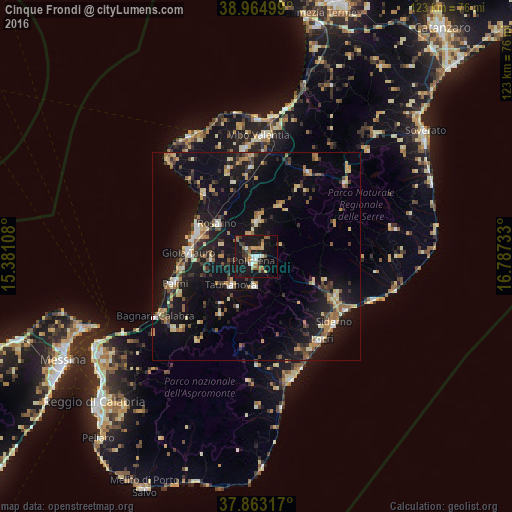
Analysis of Cinque Frondi night lights 2016
Square area 10x10 km:
 2.27%
2.27%90-99
2.92%80-89
1.3%70-79
5.84%60-69
2.92%50-59
4.71%40-49
2.92%30-39
5.68%20-29
2.44%10-19
48.7%0-9
20.29%Square area 50x50 km:
0.81%90-99
1.4%80-89
2.2%70-79
1.88%60-69
1.93%50-59
2.07%40-49
1.58%30-39
2.68%20-29
3.04%10-19
16.93%0-9
65.49%Clear (daylight) street map image can be seen on geolist.org.
Map coordinates:
38° 57' 54" North, 15° 22' 51.9" East
38° 24' 58.2" North, 16° 5' 3.1" East
37° 51' 47.4" North, 16° 47' 14.4" East
Some cities around Cinque Frondi sort by population:
• Gioia Tauro
16.3 km =10.1 mi,  273°
273°
• Palmi
21.2 km =13.2 mi,  252°
252°
• Siderno
24.6 km =15.3 mi,  131°
131°
• Rosarno
12.1 km =7.5 mi,  310°
310°
• Taurianova
9.2 km =5.7 mi,  222°
222°
• Polistena
1.5 km =0.9 mi, 218°
• Cittanova
6.9 km =4.3 mi,  183°
183°
• Gioiosa Ionica
21.6 km =13.4 mi,  117°
117°
2524985 (p: 5,988)
Sources (retrieved 2019-11-25):
» Earth at Night: Flat Maps 2012, 2016