Serra San Bruno night lights from space
Night Light of Serra San Bruno (Calabria) from space (Italy) Src. Average luminocity for 10x10km area is 8.0779% and for 50x50km: 12.6759%.
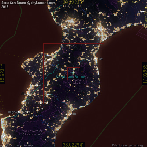
Analysis of Serra San Bruno night lights 2016
Square area 10x10 km:
 0.49%
0.49%90-99
0.81%80-89
2.6%70-79
0.97%60-69
0%50-59
0.65%40-49
1.62%30-39
0.97%20-29
0.65%10-19
0%0-9
91.23%Square area 50x50 km:
0.45%90-99
1.34%80-89
2.42%70-79
1.72%60-69
1.56%50-59
1.57%40-49
1.46%30-39
2.43%20-29
2.84%10-19
11.31%0-9
72.91%Clear (daylight) street map image can be seen on geolist.org.
Map coordinates:
39° 7' 20.4" North, 15° 37' 23.2" East
38° 34' 29.1" North, 16° 19' 34.4" East
38° 1' 22.6" North, 17° 1' 45.7" East
Some cities around Serra San Bruno sort by population:
• Vibo Valentia
22.6 km =14 mi,  299°
299°
• Polistena
29 km =18 mi,  229°
229°
• Pizzo
23.2 km =14.4 mi,  328°
328°
• Soverato Marina
23 km =14.3 mi,  57°
57°
• Roccella Ionica
28.9 km =18 mi,  167°
167°
• Cinque Frondi
27.5 km =17.1 mi, 230°
• Girifalco
29.3 km =18.2 mi,  17°
17°
• Gioiosa Ionica
27.6 km =17.1 mi,  184°
184°
2523146 (p: 6,202)
Sources (retrieved 2019-11-25):
» Earth at Night: Flat Maps 2012, 2016