Venturina night lights from space
Night Light of Venturina (Tuscany) from space (Italy) Src. Average luminocity for 10x10km area is 14.3778% and for 50x50km: 5.4681%.
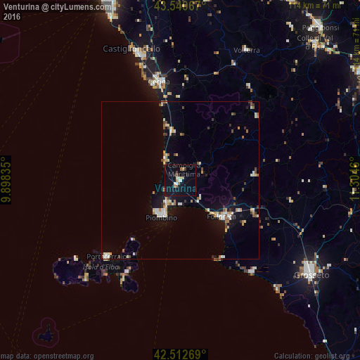
Analysis of Venturina night lights 2016
Square area 10x10 km:
 1.43%
1.43%90-99
2.38%80-89
1.27%70-79
1.9%60-69
1.43%50-59
0.79%40-49
0.63%30-39
1.75%20-29
0.95%10-19
16.03%0-9
71.43%Square area 50x50 km:
0.58%90-99
1.12%80-89
0.55%70-79
0.63%60-69
0.65%50-59
0.42%40-49
0.67%30-39
0.58%20-29
0.33%10-19
3.9%0-9
90.57%Clear (daylight) street map image can be seen on geolist.org.
Map coordinates:
43° 32' 26.4" North, 9° 53' 54.1" East
43° 1' 43.8" North, 10° 36' 5.3" East
42° 30' 45.7" North, 11° 18' 16.6" East
Some cities around Venturina sort by population:
• Piombino
13 km =8.1 mi,  208°
208°
• Cecina
31.6 km =19.6 mi,  347°
347°
• Follonica
17.4 km =10.8 mi,  130°
130°
• Rosignano Solvay-Castiglioncello
42.3 km =26.3 mi,  341°
341°
• Portoferraio
33.6 km =20.9 mi,  224°
224°
• San Vincenzo
8.4 km =5.2 mi,  325°
325°
• Massa Marittima
23.8 km =14.8 mi,  84°
84°
• Donoratico
15.9 km =9.9 mi, 349°
3164572 (p: 9,004)
Sources (retrieved 2019-11-25):
» Earth at Night: Flat Maps 2012, 2016