Rosignano Solvay-Castiglioncello night lights from space
Night Light of Rosignano Solvay-Castiglioncello (Tuscany) from space (Italy) Src. Average luminocity for 10x10km area is 25.2159% and for 50x50km: 9.2771%.
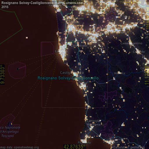
Analysis of Rosignano Solvay-Castiglioncello night lights 2016
Square area 10x10 km:
 3.02%
3.02%90-99
4.6%80-89
3.33%70-79
2.54%60-69
3.33%50-59
3.33%40-49
3.02%30-39
0.63%20-29
2.54%10-19
36.83%0-9
36.83%Square area 50x50 km:
1.42%90-99
1.82%80-89
0.9%70-79
0.93%60-69
0.75%50-59
0.76%40-49
1.03%30-39
1.24%20-29
2.73%10-19
8.68%0-9
79.74%Clear (daylight) street map image can be seen on geolist.org.
Map coordinates:
43° 53' 53.8" North, 9° 43' 58.9" East
43° 23' 22.1" North, 10° 26' 10.1" East
42° 52' 34.9" North, 11° 8' 21.4" East
Some cities around Rosignano Solvay-Castiglioncello sort by population:
• Livorno
19.4 km =12.1 mi,  332°
332°
• Cascina
33.2 km =20.6 mi,  16°
16°
• Cecina
11.3 km =7 mi,  144°
144°
• Pontedera
34.1 km =21.2 mi,  27°
27°
• Ponsacco
30.2 km =18.8 mi, 30°
• Marina di Pisa-Tirrenia-Calambrone
28.9 km =18 mi,  336°
336°
• Fornacette
33.4 km =20.8 mi, 21°
• Donoratico
26.7 km =16.6 mi,  156°
156°
3168930 (p: 19,786)
Sources (retrieved 2019-11-25):
» Earth at Night: Flat Maps 2012, 2016