Troina night lights from space
Night Light of Troina (Sicily) from space (Italy) Src. Average luminocity for 10x10km area is 3.6173% and for 50x50km: 5.0681%.
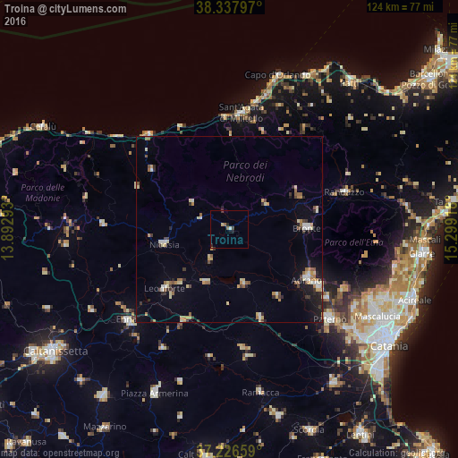
Analysis of Troina night lights 2016
Square area 10x10 km:
 0.51%
0.51%90-99
0.17%80-89
0.34%70-79
0.34%60-69
1.19%50-59
0.17%40-49
0.51%30-39
0.51%20-29
1.36%10-19
1.19%0-9
93.71%Square area 50x50 km:
0.49%90-99
0.51%80-89
0.91%70-79
0.66%60-69
0.73%50-59
0.62%40-49
0.36%30-39
0.78%20-29
0.82%10-19
1.94%0-9
92.2%Clear (daylight) street map image can be seen on geolist.org.
Map coordinates:
38° 20' 16.7" North, 13° 53' 34.5" East
37° 47' 3.7" North, 14° 35' 45.8" East
37° 13' 35.7" North, 15° 17' 57" East
Some cities around Troina sort by population:
• Adrano
24.8 km =15.4 mi,  122°
122°
• Biancavilla
28.5 km =17.7 mi, 123°
• Bronte
20.9 km =13 mi,  88°
88°
• Leonforte
23.6 km =14.7 mi,  227°
227°
• Nicosia
18.4 km =11.4 mi,  257°
257°
• Sant'Agata di Militello
31.8 km =19.8 mi,  6°
6°
• Agira
15.8 km =9.8 mi,  205°
205°
• Regalbuto
15.2 km =9.4 mi,  165°
165°
2522849 (p: 9,081)
Sources (retrieved 2019-11-25):
» Earth at Night: Flat Maps 2012, 2016