Agira night lights from space
Night Light of Agira (Sicily) from space (Italy) Src. Average luminocity for 10x10km area is 7.1514% and for 50x50km: 4.6662%.
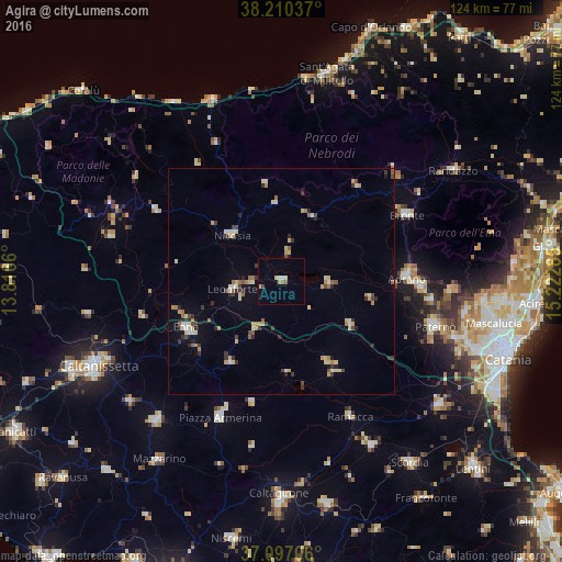
Analysis of Agira night lights 2016
Square area 10x10 km:
 0.85%
0.85%90-99
0.68%80-89
1.87%70-79
0.51%60-69
0.51%50-59
1.02%40-49
0.68%30-39
0%20-29
0%10-19
0%0-9
93.88%Square area 50x50 km:
0.38%90-99
0.34%80-89
1%70-79
0.62%60-69
0.59%50-59
0.49%40-49
0.45%30-39
1%20-29
0.64%10-19
0.82%0-9
93.66%Clear (daylight) street map image can be seen on geolist.org.
Map coordinates:
38° 12' 37.3" North, 13° 48' 59.8" East
37° 39' 20.9" North, 14° 31' 11" East
37° 5' 49.4" North, 15° 13' 22.3" East
Some cities around Agira sort by population:
• Adrano
27.6 km =17.1 mi,  88°
88°
• Biancavilla
30.6 km =19 mi, 92°
• Enna
23.8 km =14.8 mi,  245°
245°
• Leonforte
10.9 km =6.8 mi,  261°
261°
• Nicosia
15.2 km =9.4 mi,  312°
312°
• Troina
15.8 km =9.8 mi,  25°
25°
• Valguarnera Caropepe
21.2 km =13.2 mi,  212°
212°
• Regalbuto
10.5 km =6.5 mi, 92°
2525767 (p: 7,627)
Sources (retrieved 2019-11-25):
» Earth at Night: Flat Maps 2012, 2016