Sant'Agata di Militello night lights from space
Night Light of Sant'Agata di Militello (Sicily) from space (Italy) Src. Average luminocity for 10x10km area is 24.7938% and for 50x50km: 5.1854%.
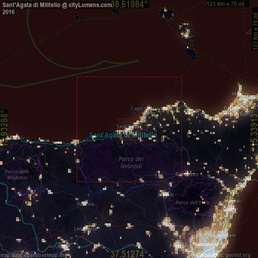
Analysis of Sant'Agata di Militello night lights 2016
Square area 10x10 km:
 1.3%
1.3%90-99
3.57%80-89
2.92%70-79
1.46%60-69
5.36%50-59
5.19%40-49
3.57%30-39
3.41%20-29
3.9%10-19
32.63%0-9
36.69%Square area 50x50 km:
0.17%90-99
0.44%80-89
0.77%70-79
0.72%60-69
0.96%50-59
0.68%40-49
0.59%30-39
1.09%20-29
0.97%10-19
5.59%0-9
88.02%Clear (daylight) street map image can be seen on geolist.org.
Map coordinates:
38° 37' 11.4" North, 13° 55' 58.4" East
38° 4' 6.2" North, 14° 38' 9.6" East
37° 30' 45.9" North, 15° 20' 20.9" East
Some cities around Sant'Agata di Militello sort by population:
• Bronte
35.6 km =22.1 mi,  150°
150°
• Capo d'Orlando
11.8 km =7.3 mi,  45°
45°
• Nicosia
41.6 km =25.8 mi,  210°
210°
• Randazzo
34.8 km =21.6 mi,  127°
127°
• Patti
30 km =18.6 mi,  72°
72°
• Troina
31.8 km =19.8 mi,  186°
186°
• Regalbuto
46.3 km =28.8 mi,  179°
179°
• Terme
46.2 km =28.7 mi,  80°
80°
2523347 (p: 9,916)
Sources (retrieved 2019-11-25):
» Earth at Night: Flat Maps 2012, 2016