Nicosia night lights from space
Night Light of Nicosia (Sicily) from space (Italy) Src. Average luminocity for 10x10km area is 6.7908% and for 50x50km: 4.2708%.
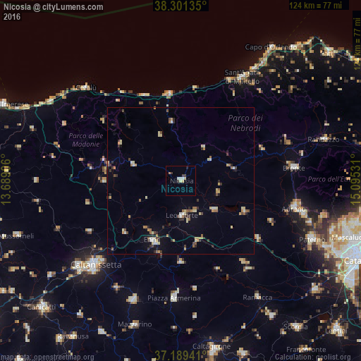
Analysis of Nicosia night lights 2016
Square area 10x10 km:
 1.36%
1.36%90-99
0.68%80-89
2.04%70-79
0.68%60-69
0%50-59
0%40-49
0.51%30-39
2.04%20-29
0.85%10-19
0%0-9
91.84%Square area 50x50 km:
0.35%90-99
0.34%80-89
0.89%70-79
0.52%60-69
0.61%50-59
0.56%40-49
0.38%30-39
0.81%20-29
0.63%10-19
0.86%0-9
94.06%Clear (daylight) street map image can be seen on geolist.org.
Map coordinates:
38° 18' 4.9" North, 13° 41' 20.6" East
37° 44' 50.9" North, 14° 23' 31.8" East
37° 11' 21.9" North, 15° 5' 43.1" East
Some cities around Nicosia sort by population:
• Enna
22.7 km =14.1 mi,  207°
207°
• Leonforte
11.7 km =7.3 mi,  177°
177°
• Troina
18.4 km =11.4 mi,  77°
77°
• Agira
15.2 km =9.4 mi,  132°
132°
• Castelbuono
33.3 km =20.7 mi,  306°
306°
• Valguarnera Caropepe
28 km =17.4 mi, 180°
• Regalbuto
24.2 km =15 mi,  116°
116°
• Gangi
17.4 km =10.8 mi,  287°
287°
2524009 (p: 10,174)
Sources (retrieved 2019-11-25):
» Earth at Night: Flat Maps 2012, 2016