Tecchiena night lights from space
Night Light of Tecchiena (Latium) from space (Italy) Src. Average luminocity for 10x10km area is 45.099% and for 50x50km: 18.8902%.
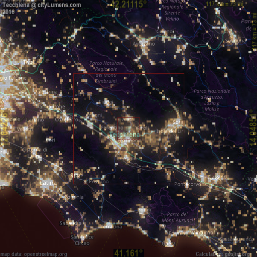
Analysis of Tecchiena night lights 2016
Square area 10x10 km:
 2.6%
2.6%90-99
4.55%80-89
6.49%70-79
3.57%60-69
4.71%50-59
16.56%40-49
12.5%30-39
16.56%20-29
21.43%10-19
11.04%0-9
0%Square area 50x50 km:
0.87%90-99
2.44%80-89
1.86%70-79
1.97%60-69
2.67%50-59
4.54%40-49
3.7%30-39
3.74%20-29
6.62%10-19
16.6%0-9
54.98%Clear (daylight) street map image can be seen on geolist.org.
Map coordinates:
42° 12' 40.1" North, 12° 38' 32.1" East
41° 41' 17.6" North, 13° 20' 43.4" East
41° 9' 39.6" North, 14° 2' 54.6" East
Some cities around Tecchiena sort by population:
• Frosinone
5.4 km =3.4 mi,  183°
183°
• Ceccano
13 km =8.1 mi,  186°
186°
• Ferentino
7.4 km =4.6 mi,  272°
272°
• Isola del Liri
20.9 km =13 mi,  90°
90°
• Alatri
4.9 km =3 mi,  355°
355°
• Fiuggi
15.8 km =9.8 mi,  320°
320°
• Anagni
16.9 km =10.5 mi,  291°
291°
• Ceprano
21.2 km =13.2 mi,  138°
138°
3165685 (p: 5,044)
Sources (retrieved 2019-11-25):
» Earth at Night: Flat Maps 2012, 2016