Sondrio night lights from space
Night Light of Sondrio (Lombardy) from space (Italy) Src. Average luminocity for 10x10km area is 22.4474% and for 50x50km: 3.9707%.
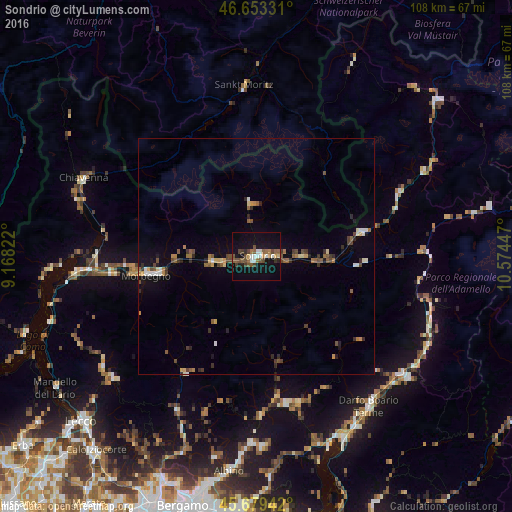
Analysis of Sondrio night lights 2016
Square area 10x10 km:
 2.7%
2.7%90-99
2.98%80-89
0.57%70-79
1.7%60-69
3.41%50-59
5.82%40-49
5.11%30-39
2.7%20-29
1.42%10-19
25.28%0-9
48.3%Square area 50x50 km:
0.24%90-99
0.49%80-89
0.34%70-79
0.4%60-69
0.5%50-59
0.83%40-49
0.81%30-39
0.66%20-29
0.72%10-19
1.88%0-9
93.12%Clear (daylight) street map image can be seen on geolist.org.
Map coordinates:
46° 39' 11.9" North, 9° 10' 5.6" East
46° 10' 6.7" North, 9° 52' 16.8" East
45° 40' 45.9" North, 10° 34' 28.1" East
Some cities around Sondrio sort by population:
• Darfo Boario Terme
39.4 km =24.5 mi,  141°
141°
• Morbegno
23.2 km =14.4 mi,  261°
261°
• Tirano
23.1 km =14.4 mi,  77°
77°
• Clusone
31.9 km =19.8 mi,  169°
169°
• Chiavenna
40.1 km =24.9 mi,  294°
294°
• Colico Piano
38.3 km =23.8 mi, 263°
• Gandino
39.8 km =24.7 mi,  177°
177°
• Cosio Valtellino
24.9 km =15.5 mi, 261°
3166397 (p: 19,208)
Sources (retrieved 2019-11-25):
» Earth at Night: Flat Maps 2012, 2016