Clusone night lights from space
Night Light of Clusone (Lombardy) from space (Italy) Src. Average luminocity for 10x10km area is 21.9568% and for 50x50km: 16.3505%.
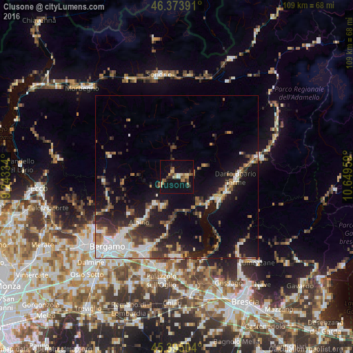
Analysis of Clusone night lights 2016
Square area 10x10 km:
 0.89%
0.89%90-99
2.53%80-89
3.72%70-79
2.83%60-69
4.61%50-59
1.79%40-49
3.42%30-39
3.13%20-29
1.49%10-19
31.25%0-9
44.35%Square area 50x50 km:
2.81%90-99
2.83%80-89
1.08%70-79
1.37%60-69
2.38%50-59
2.19%40-49
2.08%30-39
2.73%20-29
4.57%10-19
13.99%0-9
63.95%Clear (daylight) street map image can be seen on geolist.org.
Map coordinates:
46° 22' 26.1" North, 9° 14' 36" East
45° 53' 11.9" North, 9° 56' 47.3" East
45° 23' 42.1" North, 10° 38' 58.5" East
Some cities around Clusone sort by population:
• Darfo Boario Terme
18.8 km =11.7 mi,  88°
88°
• Albino
17.7 km =11 mi,  220°
220°
• Nembro
21.4 km =13.3 mi, 222°
• Costa Volpino
13.6 km =8.5 mi,  118°
118°
• Trescore Balneario
22.9 km =14.2 mi,  200°
200°
• Gandino
9.2 km =5.7 mi, 204°
• Lovere
12.5 km =7.8 mi,  130°
130°
• Pisogne
15.4 km =9.6 mi, 124°
3178541 (p: 8,032)
Sources (retrieved 2019-11-25):
» Earth at Night: Flat Maps 2012, 2016