Quarto d'Altino night lights from space
Night Light of Quarto d'Altino (Veneto) from space (Italy) Src. Average luminocity for 10x10km area is 34.697% and for 50x50km: 39.4031%.
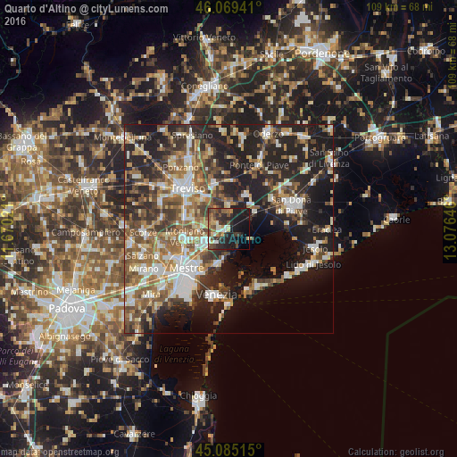
Analysis of Quarto d'Altino night lights 2016
Square area 10x10 km:
 3.33%
3.33%90-99
4.39%80-89
3.64%70-79
4.55%60-69
3.64%50-59
6.06%40-49
8.64%30-39
8.18%20-29
15%10-19
28.03%0-9
14.55%Square area 50x50 km:
5.95%90-99
7.4%80-89
3.91%70-79
4.23%60-69
6.4%50-59
7.53%40-49
6.39%30-39
6.52%20-29
12.88%10-19
19.41%0-9
19.38%Clear (daylight) street map image can be seen on geolist.org.
Map coordinates:
46° 4' 9.9" North, 11° 40' 12.8" East
45° 34' 46" North, 12° 22' 24" East
45° 5' 6.5" North, 13° 4' 35.3" East
Some cities around Quarto d'Altino sort by population:
• Mogliano Veneto
10.5 km =6.5 mi,  255°
255°
• Marcon-Gaggio-Colmello
6 km =3.7 mi,  253°
253°
• Casale sul Sile
4.1 km =2.5 mi,  297°
297°
• Preganziol
10.9 km =6.8 mi,  282°
282°
• Roncade
4.7 km =2.9 mi,  2°
2°
• Silea
10.2 km =6.3 mi,  324°
324°
• Frescada
12 km =7.5 mi, 297°
• Dosson
11.2 km =7 mi, 304°
3169700 (p: 5,880)
Sources (retrieved 2019-11-25):
» Earth at Night: Flat Maps 2012, 2016