Praia a Mare night lights from space
Night Light of Praia a Mare (Calabria) from space (Italy) Src. Average luminocity for 10x10km area is 19.5714% and for 50x50km: 5.779%.
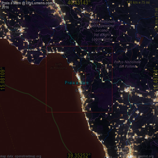
Analysis of Praia a Mare night lights 2016
Square area 10x10 km:
 2.89%
2.89%90-99
2.72%80-89
1.19%70-79
3.06%60-69
1.7%50-59
2.72%40-49
1.53%30-39
3.06%20-29
2.21%10-19
25.51%0-9
53.4%Square area 50x50 km:
0.3%90-99
0.7%80-89
0.76%70-79
0.71%60-69
0.86%50-59
1.05%40-49
0.72%30-39
0.97%20-29
1.02%10-19
4.27%0-9
88.64%Clear (daylight) street map image can be seen on geolist.org.
Map coordinates:
40° 25' 53.1" North, 15° 4' 51.9" East
39° 53' 38.8" North, 15° 47' 3.2" East
39° 21' 9.1" North, 16° 29' 14.4" East
Some cities around Praia a Mare sort by population:
• Castrovillari
36.7 km =22.8 mi,  103°
103°
• Cassano Allo Ionio
48 km =29.8 mi,  105°
105°
• Scalea
9.8 km =6.1 mi,  173°
173°
• Sapri
23.9 km =14.9 mi,  327°
327°
• Senise
51.3 km =31.9 mi,  56°
56°
• Belvedere Marittimo
31.3 km =19.4 mi, 167°
• Roggiano Gravina
44.6 km =27.7 mi,  133°
133°
• Lagonegro
26.1 km =16.2 mi,  355°
355°
2523687 (p: 6,470)
Sources (retrieved 2019-11-25):
» Earth at Night: Flat Maps 2012, 2016